![]()
![]()
|
|
|
THE ESTUARY OF THE ADUR THE interest in the Sussex coastline first shown by Ballard in 19101 has since been echoed by several workers-historians, engineers, and geographers among them-for the Sussex coast has changed greatly during historical time and provides a laboratory in which the 'processes of coastal evolution may be seen at work. Though work has been done on the estuary of the Adur, it is the object of this paper to put forward new evidence, and to use it to offer a fresh interpretation of the problem and, by implication, of the origin of the coastal features of Sussex as a whole. The processes at work are simple.2 The action of the waves, dragging down the shingle of the beach on one wave and throwing it up on the next, has the effect, on a coast where the winds are derived dominantly from the west and south-west, of driving the beach material slowly east in a zigzag motion along the shore. The process acts to smooth out all irregularities and to produce a smooth, uniform line, at right angles ultimately to the dominant direction from which the waves are derived. In Sussex this process is already far advanced, but it meets obstacles of three kinds - the resistance of harder rock, producing the headland of Beachy Head; the shelter from wave action offered by offshore islands, pre-serving the Chichester inlets and forming Selsey Bill in the lee of the Isle of Wight; and the action of the tide, flowing twice daily in and out of the inlets in the coast. The harbours in the west and the river mouths in the central part of the coast are kept open by this means. Their size depends on the interaction of several variables - the power of longshore drift, the amount of material available for beach-building, the openness of the entry to wave action, and the volume of water passing in and out of the `tidal compartment' in the land, scouring the entrance clear of the beach material which longshore drift is constantly passing across and into it.
The retreat of the ice after the last Ice Age and the subsequent rise of sea-level in Neolithic times left Sussex with an intricate and deeply embayed coastline which evidence shows was rapidly worn back. The theoretical pattern of coastal evolution would lead us to expect first a trimming of the headlands, then the formation of bay-mouth bars from the resulting detritus, and thirdly the silting up of the drowned valleys behind. The cliff and bar coast would soon form a continuous line, which would be driven landward as a whole, so that the pro-portion of cliff-coast to bar-coast would steadily increase as erosion reached the heads of the inlets. It seems highly probable that such a course of events took place in Sussex. It is surprising, therefore, that of the many workers who have investigated the Sussex coast only Ward1 and to some extent Ballard2 consider the problem as a whole. Ward postulates an offshore bar, driven onshore, to account for the accumulation of shingle on the coast. All detailed work, however, is based on the assumption that all coastal features are due to erosion and longshore drift of shingle, onshore movement being largely neglected. If we group together all the research done on the subject, we find that we are expected to believe that all estuaries were probably still open in Roman times, but that at a time about the date of the Norman Conquest Selsey was already linked to the mainland by a shingle bar,3 the Arun was diverted up to eight miles to the east, Broadwater Rife was still open, the Adur followed a direct and open course to the sea ,4
the Ouse was diverted as far east as it could be to Seaford Head,1 and Pevensey Levels were still an open harbour similar to Portsmouth today.2 Certain of these conclusions are incontrovertible. There is no reason to dispute either Bede's account of Selsey or Morris's well-documented account of the Ouse. There is extant a description of the port of Seaford in 1058 describing the place as having a narrow, difficult entrance, with a wide safe harbour within.3 Salzman's account of the evolution of Pevensey Levels is excellently documented. The prevailing accounts of the evolution of the Adur and Arun entrances are
more difficult to reconcile. The suggested deflexion of the Arun is lightly
based on a tradition that the river was formerly diverted to Pende, in Lancing
parish .4 Some weight is given to the suggestion by occasional
mentions of a port at Pende from 1359 to 1420.5 Morris equates Pende
with the name Pen Hill at Lancing, south of which a lagoon behind the beach was
marked as `Penhowse' on a map of 1587.6 Furthermore, there is a
reference in Maskell's manuscript survey of Sussex in 1608 as follows:
While this might suggest the existence of a harbour, it is no proof of the deflexion of the Arun thus far, and, as we shall see, there are strong indications that such a deflexion was impossible. Regarding the Adur itself, the theory of its evolution presented by Cheal,1 and strongly supported in the main by Morris, is based on the undoubted prosperity of the port in early medieval times and its subsequent decline, and in the great degree of coast erosion suffered here in the fourteenth and fifteenth centuries. This latter, they hold, would not be possible if the town were at that time protected by a shingle bar, and hence they postulate that the entrance was wide open and direct to the sea throughout the greater part of the Middle Ages. In further support Cheal points out that the original harbour of Shoreham lay in a creek behind the town, in a position sheltered from the open river, and also adduces as evidence the untoward position of the High Street at Shoreham, which he regards as the sole remnant of an ancient high road from Brighton, through the lost village of Aldrington, to a ferry across the Adur at New Shoreham. Lastly, their theory is based on cartographical evidence between 1587 and 1783, suggesting a gradual advance of the spit along the coast between the fourteenth and eighteenth centuries. It is not proposed here to consider the case point by point, but merely to question certain of the conclusions reached, and by a revaluation of Cheal and Morris's evidence, together with some new sources which have come to light, to offer an alternative explanation perhaps more in keeping with this new evidence and with the observed facts of coastal evolution as a whole.
A number of prima facie objections may immediately be offered to Cheal and Morris's reasoning. In the first place, it is unlikely that an open entrance, unfettered by shingle, could have existed on a coast composed of such incoherent materials so long after the original submergence. This is rendered the more unlikely by an undoubted accumulation of tidal marsh from an early date on the west side of the estuary in the Lancing Salts area.1 Furthermore, it would appear that the channel of the river has always hugged the east bank, which strongly suggests eastward deflexion by shingle.
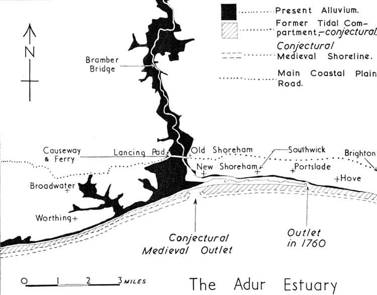
Secondly, it seems improbable that a high road from Brighton (a mere fishing-town) should run to New Shoreham to seek a ferry there, when an ancient road much less encumbered by physical difficulty paralleled it to the much shorter ford over the same river at Old Shoreham. Furthermore, opposite New Shoreham is only marsh, and the ferry which did run from the town ran to the Lancing Pad, as did the Old Shoreham ferry.2 The Adur is now, and was in 1680,3 fordable at low water, though at some risk, but before the reclamation of the marshes no road could have continued this ford towards Lancing. Therefore the very existence of this ferry would seem to depend on the adequate protection of a bar across the entrance.
More significant than this, however, is the form of the coast east of Shoreham. Examination of maps shows clearly that between Shoreham and Southwick the land declines steadily seawards to reach tide-level at about the line of the present shore of the harbour, while farther to the east a great Coombe Rock fan at the foot of Mile Oak valley is truncated by a cliff of a markedly arcuate form, suggesting river or tidal meander action. Farther east, at Hove, is a short low stretch, beyond which, at Brighton, is the truncated head of the great Coombe Rock fan that must formerly have emerged from this valley. The Armada Survey of 1587. showed a lagoon behind the beach at Southwick and also a series of lagoons ex-tending west of the Adur past Worthing to Goring. The first minute book of the Shoreham Harbour Commissioners (1760-1812) has a number of references to areas of salterns and reclaimed land on the north bank of the harbour, much of which was overwhelmed by the in-creased tidal flow that resulted from the opening of the new entrance in 1763. One parcel of land at Southwick was referred to as the `Old Salts'.1 It is unlikely that it would have this name if 150 years before the site had been open sea, as suggested by Cheal and Morris. More probably it represents the lagoon (and adjoining marsh) at Southwick of the map of 1587, then separated by a shingle bank from the sea, but by 1760 fronting on the river. There was also a tidal creek just to the east of Shore-ham at the common called `The Ham'.2 Thus Shoreham would appear in former times to have stood on a peninsula of firm land, and it seems very improbable that there was ever any great extent of firm land between the town and Aldrington.
There is also other evidence to suggest the former existence of a belt of
marsh fronting the coast behind the protection of a shingle bar. The most direct
evidence is of eighteenth-century date, particularly the 2 in. to the mile map
of Yeakell and Gardner, drawn in 1778-83. This shows a belt of marsh, far wider
than at present, extending behind the shingle from Goring to the harbour, which
continued it almost to Hove. Today this belt, rapidly narrowing as the bar is
driven onshore, re-mains only at Lancing and for a short stretch west of
Worthing.1 The beach reached the land at Worthing shortly before
1814, when Earlier a wide meadow had lain between the mainland and the beach .3 East of the river, also, the undercliff at Brighton had housed the fishing settlement until 1666, when a great storm, perhaps driving the beach right on to the land, destroyed the lower town. It may also be that the great flooding of land recorded in the Nonae Rolls between 1292 and 13404 was due to the overwhelming of formerly reclaimed land by the sea in a period of exceptional storminess, perhaps accompanied by a rise in sea-level. That the great loss of land in Pagham Harbour was so caused is now widely held.5 The loss of 400 acres at Hooe is similarly accounted for. Losses of 150 acres at Goring, 60 acres at Portslade, 40 acres at Aldrington, 150 acres at Hove, 50 acres at Brighton, and 50 acres at Rotting-dean may all be, in part, losses of reclaimed land.
It seems clear that an offshore bar must formerly have fronted the coast on either side of the Adur, and that behind this lay marsh and reclaimed land extending to the edge of the firm land. This edge may have formed a cliff, as at Brighton - the remnant perhaps of earlier erosion before the offshore bar developed, and perhaps also due to erosion by waves and tidal currents within the lagoons. It would seem that the whole broad embayment from Goring to beyond Brighton was thus fronted. Firm land would have bordered the open sea only at the eastern and western limits, and in this connection the pattern of field boundaries between Worthing and Littlehampton is noteworthy. Here the whole pattern of land division is rectangular in form, and bears a striking similarity to the rectangular land division at Ripe, which has been the subject of speculation by I. D. Margary.1 The east-west element of the pattern is, how-ever, not quite accordant with the coast, having a broad bulge southward west of Goring. This may well represent a pattern parallel to the coast of a former extension of land in the interfluve between the Arun and Adur rivers. If such a bar existed, however, it might at first sight appear difficult to reconcile the evidence of erosion at Shoreham, and also the cartographical evidence as interpreted by Cheal and Morris. However, if it be under-stood that the term `sea' in almost all accounts of coast protection and erosion as late as 1800 can mean any sea-water, and not merely the open sea ,2 the problem is considerably easier. It is well known that the inning of tidal lands inevitably reduces the tidal compartment of an estuary or river, and so also reduces the power of the tide to scour the bed and maintain a good, broad entrance to the open sea, against the processes of beach-building and longshore drift. Such was the case in the inning of Pevensey Levels, and the worsening of the river ports was attributed to unwise inning by many
engineers.1 Rennie, in particular, held that the loss of water flowing off the salt marshes on the ebb tide was a major cause in the loss by the River Adur of power to keep its channel clear: `From the best information I have been able to procure, the entrance or mouth of the harbour was, about the year 1750, 3½ miles to the eastward of the town of New Shoreham, and the space, or receptacle which was formed between the bank of beach before mentioned and the shore, must have contained at spring tides at least 3,250,000 tons of water besides what went into the space or channel of the Adur above Shoreham Bridge; and this quantity was thrown into it twice in every 24 hours; whereas the produce of the Adur (river) in its present state does not exceed 650,000 tons in the same time, which is not above a tenth part of the former. Thus it appears that the fresh water had but a small share in keeping the harbour open.'2 The proportion formed by the fresh water must have been far smaller in former times, for by this time, of the great extent of tidal land formerly existing, only the main channels of the rivers remained unreclaimed. There can be little doubt that the wide entrances of the western harbours are maintained solely by the tidal ebb and flow.3 At Shoreham, therefore, with fairly deep water off-shore,4 we might expect a wide deep channel to have existed in earlier times when the tidal levels were un-reclaimed right into the Weald. The great medieval bridge at Bramber, unearthed in 1839, with four great stone arches and massive cutwaters, and subsidiary bridges to east and west, were built to span, not the present tiny stream, but the strong tidal ebb and flow from the tidal compartment of the river inland.5 This ebb and flow would have been far greater at the entrance, and could
have maintained a direct wide entrance to the sea, though the shingle bar in all probability stretched along the coast to east and west. The lagoons behind this bar, where not reclaimed, would also furnish tidal water.1 It seems probable, therefore, that a wide entrance could easily have been maintained, though perhaps diverted slightly to the east, while the river was in its un-reclaimed state. As the reclamations proceeded, however, and the offshore bar was driven shorewards, the tidal compartment would be reduced, and the ebb and flow, now maintaining only a smaller entrance, would suffer increasing diversion to the east. In so doing the tidal channel also would be deflected to the east, bringing the whole of its still considerable erosive power against the land and the town of Shoreham. Particularly if this took place in a period of storminess (when the bar would be driven onshore very rapidly, and probably frequently breached) and during a slight rise of sea-level,2 it is easy to see how the town would be eroded, and land about it submerged, as the evidence collected by Cheal and Morris indubitably proves. In the writer's opinion, a stage in this process is re-presented in the 1587 map, when only remnants of the lagoon to the east are left, separated from the river, very naturally, by a bank of beach. The next reliable map is the Admiralty Survey of3 1698, by which time the re-mainder of the lagoon to the east was largely destroyed. By the date of Budgen's map (1724)4 the mouth was diverted east beyond Portslade, but a small channel ran east of the entrance, perhaps the remnant of a lagoon. These maps, however, are far too inaccurate for any firm conclusions to be drawn from them.
The writer feels that this provides a working hypo-thesis of the evolution of the Sussex coast. It seems to accord well with the observed facts, and is a valuable aid in understanding the pattern of coastal settlement. The retreat of the shore-line, which is still in progress, has been a factor of importance in the development of coastal resorts, and great efforts have been made to arrest its progress. From
Sussex Archaeological Collections 90,
1951-52 |
|
Copyright © Martin Snow
2002 All rights reserved |